Portal:Tropical cyclones
The Tropical Cyclones Portal
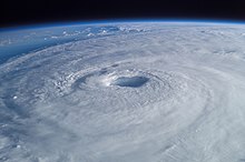
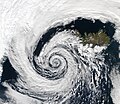
A tropical cyclone is a storm system characterized by a large low-pressure center, a closed low-level circulation and a spiral arrangement of numerous thunderstorms that produce strong winds and heavy rainfall. Tropical cyclones feed on the heat released when moist air rises, resulting in condensation of water vapor contained in the moist air. They are fueled by a different heat mechanism than other cyclonic windstorms such as Nor'easters, European windstorms and polar lows, leading to their classification as "warm core" storm systems. Most tropical cyclones originate in the doldrums, approximately ten degrees from the Equator.
The term "tropical" refers to both the geographic origin of these systems, which form almost exclusively in tropical regions of the globe, as well as to their formation in maritime tropical air masses. The term "cyclone" refers to such storms' cyclonic nature, with anticlockwise rotation in the Northern Hemisphere and clockwise rotation in the Southern Hemisphere. Depending on its location and intensity, a tropical cyclone may be referred to by names such as "hurricane", "typhoon", "tropical storm", "cyclonic storm", "tropical depression" or simply "cyclone".
Types of cyclone: 1. A "Typhoon" is a tropical cyclone located in the North-west Pacific Ocean which has the most cyclonic activity and storms occur year-round. 2. A "Hurricane" is also a tropical cyclone located at the North Atlantic Ocean or North-east Pacific Ocean which have an average storm activity and storms typically form between May 15 and November 30. 3. A "Cyclone" is a tropical cyclone that occurs in the South Pacific and Indian Oceans.
Selected named cyclone -
Typhoon Abby, known in the Philippines as Typhoon Diding, was an extremely powerful tropical cyclone which was the second typhoon to strike Japan within a span of a few days in August 1983. First noted southeast of Guam on July 31, development of this system was initially slow to occur; it was first classified on August 5, and was upgraded into a tropical storm the next day. Intensification was rapid as Abby slowly recurved northward on August 7 and 8. After reaching peak intensity with winds of 140 mph (225 km/h) early on August 9, Abby slowly weakened, though the storm briefly re-intensified on August 11. By August 14, winds had diminished to 100 mph (160 km/h). Abby finally weakened back into a tropical storm on August 17 not long after making landfall in Japan. The following day, Abby completed the transition to an extratropical cyclone after moving through central Japan. However, meteorologists continued monitoring the storm for six more days.
In the Philippines, heavy rainfall resulted in a landslide that crushed a house in Manila, killing three people. Two others drowned due to rough seas. Typhoon Abby also brought several consecutive days of rain to southern and central Japan, resulting in widespread damage. Commercial traffic by land, sea, and air was also paralyzed by the cyclone, stranding 25,900. Moreover, over 10,000 fishing boats took refuge in harbors. Around 3,400 homes were flooded and 24 homes were either damaged or destroyed. Additionally, 89 roads were also damaged. About a dozen people were injured during a flash flood that destroyed three houses. Three more dwellings were washed away when a river overflowed its banks. Nationwide, 27 people were hurt and two persons were killed. One person was listed as missing. (Full article...)Selected article -
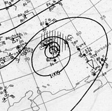
The Okeechobee hurricane of 1928, also known as the San Felipe Segundo hurricane, was one of the deadliest hurricanes in the recorded history of the North Atlantic basin, and the fourth deadliest hurricane in the United States, only behind the 1900 Galveston hurricane, 1899 San Ciriaco hurricane, and Hurricane Maria. The hurricane killed an estimated 2,500 people in the United States; most of the fatalities occurred in the state of Florida, particularly in Lake Okeechobee. It was the fourth tropical cyclone, third hurricane, the only major hurricane of the 1928 Atlantic hurricane season, and remains the deadliest disaster in Florida’s history to date. It developed off the west coast of Africa on September 6 as a tropical depression, but it strengthened into a tropical storm later that day, shortly before passing south of the Cape Verde islands. Further intensification was slow and halted late on September 7. About 48 hours later, the storm strengthened and became a Category 1 hurricane on the Saffir–Simpson hurricane wind scale. Still moving westward, the system reached Category 4 intensity before striking Guadeloupe on September 12, where it brought great destruction and resulted in 1,200 deaths. The islands of Martinique, Montserrat, and Nevis also reported damage and fatalities, but not nearly as severe as in Guadeloupe.
Around midday on September 13, the storm strengthened into a Category 5 hurricane and peaked with sustained winds of 160 mph (260 km/h). About six hours later, the system made landfall in Puerto Rico; it remains the only tropical cyclone on record to strike the island at Category 5 intensity. Very strong winds resulted in severe damage in Puerto Rico; 24,728 homes were destroyed and 192,444 were damaged throughout the island, leaving over 500,000 people homeless. Heavy rainfall also led to extreme damage to vegetation and agriculture. On Puerto Rico alone, there were 312 deaths and about US$50 million ($887 million today) in damage. While crossing the island and emerging into the Atlantic, the storm weakened slightly, falling to Category 4 intensity. It began crossing through the Bahamas on September 16, where it resulted in 18 fatalities. (Full article...)Selected image -
Selected season -
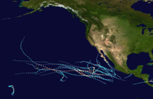
The 2016 Pacific hurricane season was tied as the fifth-most active Pacific hurricane season on record, alongside the 2014 season. Throughout the course of the year, a total of 22 named storms, 13 hurricanes and six major hurricanes were observed within the basin. Although the season was very active, it was considerably less active than the previous season, with large gaps of inactivity at the beginning and towards the end of the season. It officially started on May 15 in the Eastern Pacific (north of the Equator and east 140°W), and on June 1 in the Central Pacific (from 140°W to the International Date Line); they both ended on November 30. These dates conventionally delimit the period of each year when most tropical cyclones form in these regions of the Pacific Ocean. However, tropical development is possible at any time of the year, as demonstrated by the formation of Hurricane Pali on January 7, the earliest Central Pacific tropical cyclone on record. After Pali, however, no tropical cyclones developed in either region until a short-lived depression on June 6. Also, there were no additional named storms until July 2, when Tropical Storm Agatha formed, becoming the latest first-named Eastern Pacific tropical storm since Tropical Storm Ava in 1969.
Hurricane Darby brushed the Hawaiian islands as a tropical storm causing only minor damage; while hurricanes Lester and Madeline also threatened to make landfall in Hawaii but weakened significantly before approaching the islands. Tropical Storm Javier and Hurricane Newton both made landfall in Mexico, with the latter being responsible for at least nine fatalities as it came ashore near Baja California Sur. Hurricane Ulika was a rare and erratic storm which zig-zagged across 140°W a total of three times. Hurricane Seymour became the strongest storm of the season, forming in late October. Finally, in late November, Hurricane Otto from the Atlantic made an unusual crossing over Central America, emerging into the East Pacific as a moderate tropical storm but dissipated shortly after. Damage across the basin reached $95 million (2016 USD), while 11 people were killed by Celia and Newton overall.
(Full article...)Related portals
Currently active tropical cyclones

Italicized basins are unofficial.
- North Atlantic (2024)
- No active systems
- East and Central Pacific (2024)
- No active systems
- Mediterranean (2023–24)
- No active systems
- South-West Indian Ocean (2023–24)
- No active systems
- Australian region (2023–24)
- No active systems
- South Pacific (2023–24)
- No active systems
- South Atlantic (2023–24)
- No active systems
Last updated: 18:32, 26 May 2024 (UTC)
Tropical cyclone anniversaries

May 28
- 1960 - Tropical Storm Lucille and a non-tropical low merged just off Luzon in the Philippines. The non-tropical disturbance killed nearly 300 people in the Manila area.
- 2018 - Tropical Storm Alberto (pictured) makes landfall over Laguna Beach, Florida. Alberto becomes the most damaging pre-season Atlantic tropical cyclone, with estimated damages of US$125 million.

May 29
- 1958 - Typhoon Phyllis reached its peak intensity with 295 km/h (185 mph) winds, becoming the strongest typhoon ever recorded in the month of May.
- 1963 - A powerful cyclone struck what is now Bangladesh, killing 11,520&bsp;people.
- 2016 - Tropical Storm Bonnie (pictured) made landfall as a tropical depression over South Carolina. Bonnie brought heavy rainfall to the Southeastern United States, causing only US$640,000 in damages.

May 30
- 1959 - Tropical Storm Arlene made landfall in Louisiana as a minimal tropical storm, causing $500,000 worth of damage in the Southeastern United States.
- 2008 - Tropical Storm Alma (pictured) affects much of Central America with torrential rainfall. Four people died while seven people remained missing from the storm. Damages were estimated to be about US$35 million.
Did you know…
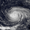


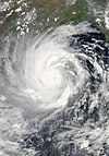
- …that the Joint Typhoon Warning Center considers that Typhoon Vera (pictured) of 1986 is actually two distinct systems, formed from two separated low-level circulations?
- …that Hurricane Agatha (pictured) was the strongest Pacific hurricane to make landfall in Mexico in May since records began in 1949?
- …that Cyclone Raquel (track pictured) travelled between the Australian and South Pacific basins between the 2014–15 and 2015–16 seasons, spanning both seasons in both basins?
- …that Cyclone Amphan (pictured) in 2020 was the first storm to be classified as a Super Cyclonic Storm in the Bay of Bengal since 1999?
General images -

Topics
Subcategories
Related WikiProjects
WikiProject Tropical cyclones is the central point of coordination for Wikipedia's coverage of tropical cyclones. Feel free to help!
WikiProject Weather is the main center point of coordination for Wikipedia's coverage of meteorology in general, and the parent project of WikiProject Tropical cyclones. Three other branches of WikiProject Weather in particular share significant overlaps with WikiProject Tropical cyclones:
- The Non-tropical storms task force coordinates most of Wikipedia's coverage on extratropical cyclones, which tropical cyclones often transition into near the end of their lifespan.
- The Floods task force takes on the scope of flooding events all over the world, with rainfall from tropical cyclones a significant factor in many of them.
- WikiProject Severe weather documents the effects of extreme weather such as tornadoes, which landfalling tropical cyclones can produce.
Things you can do
 |
Here are some tasks awaiting attention:
|
Wikimedia
The following Wikimedia Foundation sister projects provide more on this subject:
-
Commons
Free media repository -
Wikibooks
Free textbooks and manuals -
Wikidata
Free knowledge base -
Wikinews
Free-content news -
Wikiquote
Collection of quotations -
Wikisource
Free-content library -
Wikiversity
Free learning tools -
Wikivoyage
Free travel guide -
Wiktionary
Dictionary and thesaurus


